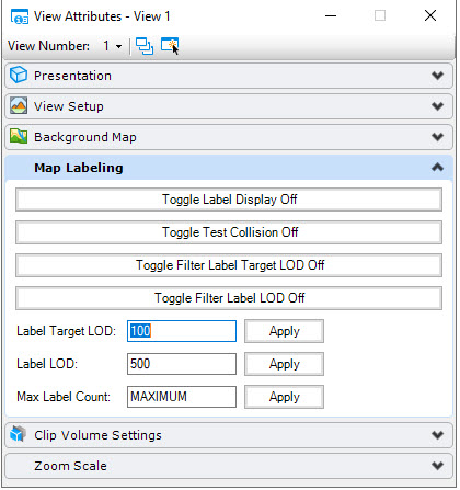
Label Collision Detection
Label collision testing is described as a label to draw is range tested against labels previously drawn in the view. If there is a collision, then the current label is not drawn. Collision testing is enabled by default for all views. The image below shows collision testing disabled on the left and enabled on the right.

To enable or disable collision testing:
- The key-in mdl command setTestLabelCollision viewNumber ON|OFF controls the testing state. The key-in changes the state for the given view number. For example:
- To disable all collision testing for all views, set the configuration variable MS_GEOXFM_LABEL_NOCOLLISIONTEST in your environment and restart. For example:
To control the volume of labels in a view:
- Labeling in a view may be controlled by specifying a maximum number of labels for a view. Default value is MAX.
- Change value with key-in: mdl command setMaxLabels viewNumber MAX/#. The key-in changes the value for the given view number. For example:
- To set a maximum label default value for all views, set the configuration variable MS_GEOXFM_LABEL_MAXCOUNT in your environment and restart Map For example:
To set the label legibility and level of detail (LOD):
- Labeling in a view may be controlled by specifying a minimum LOD number of labels for a view. The default value is 500.0. This value is compared to the label range block extent squared value. The label is drawn if the label value is greater than or equal to this minimum value. NOTE: If the element to label does not meet the MicroStation view minimum LOD value, then no label is generated for this element. The default MicroStation view minimum LOD value is 50.0.
- Change MinLOD value with key-in: mdl command setLabelsMinLOD viewNumber DEFAULT/#. The key-in changes the value for the given view number. For example:
- mdl command setLabelsMinLOD 1 DEFAULT resets the minimum LOD of labels drawn in view 1 to the default value.
- To set a MinLOD default value for all views, set configuration variable MS_GEOXFM_LABEL_DEFAULTMINLOD in your environment and restart Map. For example:
- Change the enabled state of MinLOD testing with the key-in: mdl command setLabelsFilterLOD viewNumber ON|OFF. The key-in changes the state for the given view number. For example:
- To disable all MinLOD testing for all views, set configuration variable MS_GEOXFM_LABEL_NOFILTERLOD in your environment and restart Map. For example:
To use the Map Labeling view attributes: